This information has been reviewed by the Environment Agency. We plan to update it on a continuous basis; If you’re a local authority officer and have questions that aren’t covered on this page, you’re welcome to join our PAS BNG Forum for LPA’s. The network includes an online forum where you can post questions, discuss issues, and share knowledge. The information contained here is produced by the PAS Team and It does not represent official Government policy or guidance.
Overview
The watercourse module, is a biodiversity accounting module for watercourses within the statutory biodiversity metric tool. It is used to calculate biodiversity gains and losses for rivers, streams, and other waterbodies, and is designed to support the Environment Act’s provisions for mandatory biodiversity net gain where a development falls within 10m of a watercourse.
The PAS team has been working with the Environment Agency for some years to develop resources and support in this area, even before BNG became mandatory. In March 2023, we hosted a session with the Environment Agency and Cartographer Studios, providing training specifically for local government planners and ecologists. This introduced attendees to the module, its rules and principles, and guidance on using an optional reviewer checklist.
In October 2024, the PAS team hosted a follow-up session with the Environment Agency and Natural England, offering a deeper exploration of the watercourse module. This session broadened understanding of watercourses, with a focus on technical considerations such as encroachment, opportunities for nature recovery, and highlighting existing technical guidance and resources available to local government officers. A recording of this October 2024 deep dive session is available further down this page.
Building on this work, in August 2025 the PAS team collaborated with the Environment Agency to consolidate key challenges around applying the watercourse module within day-to-day planning applications. Drawing on queries and discussions gathered over the past two years; we have developed an updated training resource designed for local government planners and ecologists. The pre-recorded session takes viewers through a step-by-step process for reviewing planning applications involving waterbodies, using an optional reviewer checklist as a central guide. It also places applications in a wider ecological context, helping officers to understand what to look out for during pre-application, validation, and full review stages. While aimed primarily at planners and ecologists with a basic understanding of BNG and the statutory biodiversity metric tool, the training is also relevant to those with broader roles in the planning process.
You can access the pre-recorded training session below, along with the reviewer checklist. If you have any questions pertaining to this resource, please get in touch via email at [email protected]
Environment Agency watercourse surgery (October 2025)
On 20th October 2025, colleagues from the Environment Agency joined the PAS Fortnightly Drop-In to deliver a watercourse surgery for members of the PAS BNG Forum. A set of questions and answers from that session are provided below.
Training resources for local government practitioners
Requirements and responsibilities
At the pre-application stage, LPAs should advise developers if the watercourse module will be required, as the completed module must accompany any planning application. The Environment Agency is not a statutory consultee on BNG and will not routinely provide comments on planning applications subject to BNG. Where the watercourse module is applied, a 10% uplift in watercourse units must be demonstrated, and these units cannot be traded across other habitat types. Where other habitats such as hedgerows or area-based habitats are present, their uplift must be achieved separately. See Table 2, under the biodiversity metric rules and principles section within the Statutory Biodiversity Metric User Guide (SBMUG).
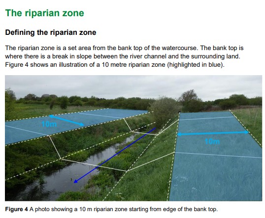
All watercourses that fall within the red line boundary must be included within the relevant metric. In addition, where the boundary extends into the riparian zone, adjacent watercourse lengths must be included even if the channel itself lies outside the boundary. The riparian zone is defined as 10m from bank top for rivers, streams and canals, and 5m for ditches. Culverts do not have a riparian zone beyond their banks, so they are only included if the culverted channel lies within the red line boundary. You can find further information regarding the riparian zone, on pg 43 of the SBMUG.
Scope of application
The watercourse module applies to priority rivers, other rivers and streams, canals, ditches, and culverts. Lakes that are fed by and drain into rivers should be assessed through the Area Habitat Metric, while natural springs are included under the headwaters section of the River Condition Assessment (RCA). Headwaters and ephemeral sections, including chalk streams that naturally dry out, should still be assessed as part of the watercourse module.
Ditches must be included where the site boundary covers the feature or its riparian zone. Where survey evidence confirms that no natural processes occur, this should be recorded with supporting photographs. An RCA is not required for ditches. Canals are defined as artificial waterbodies created for navigation, whether currently navigable or not. Care must be taken in identifying headwaters, as many are ephemeral, and caution is required when interpreting main river mapping, as drainage ditches can often be designated as Main Rivers. Tables 10-11 within the SBMUG, provide further guidance on habitat classification.
The riparian zone and BNG
The riparian zone (as defined within the statutory biodiversity metric user guide, shown in the snapshot below) is critical to how rivers function. Habitats such as wet woodland within this zone influence processes by supplying material and supporting ecological connectivity. The RCA incorporates the riparian zone in order to inform the watercourse module, while the Area module assesses the habitat within the riparian zone in its own right. This ensures that there is no double-counting and that habitats are treated consistently.
Watercourses and strategic significance
Strategic significance is primarily determined by whether restoration actions have been identified for the watercourse. Local Nature Recovery Strategies will be the principal source of this information. In the interim, River Basin Management Plans, Catchment Plans, Shoreline Management Plans, Estuary Strategies and similar documents should be consulted. Nature-based solutions such as willow spiling, which are intended to restore river condition or reinstate natural processes, are not considered to represent encroachment. Outfalls, however, are considered encroachment where they are located within 4m of the bank top and must therefore be included in the watercourse module calculations.
Qualifications, training and practical considerations
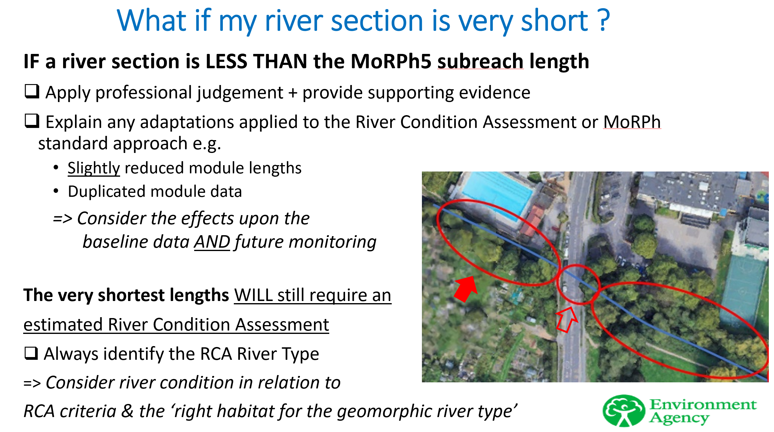
RCAs must be carried out by qualified assessors. Evidence of qualification should be presented within the assessor’s report, either in the assessor’s comments or on the front page and may be supported by a screen capture showing the qualification. There is currently no indication of a shortage of qualified assessors, as training has been available for three years with consistent uptake across the industry. The RCA methodology is based on the MoRPh approach but is distinct from it.
For small sites, the Small Sites Metric may be completed by a competent person, and a qualification in RCA is not required since rivers and streams are excluded from this metric tool.
Retained, enhanced or lost habitat
Within the main metric, rivers and riparian zones may be recorded as retained, enhanced or lost. Where a channel has been degraded by development, it should be recorded as “created” rather than “retained” or “enhanced.”
Estuaries and de-minimis
For estuarine situations, such as the installation of jetties, the de-minimis exemption may sometimes apply, though impacts on intertidal habitats must be carefully assessed. The area and watercourses modules could both apply around estuaries and coastal areas:
- BNG is only applicable down to Mean Low Water. Subtidal areas of estuaries are not included.
- The area habitat module for intertidal habitat can be used in areas within the Transitional and Coastal Waterbody (TRAC) waterbody (Water Environment Regulations) that are between Mean High Water and Mean Low Water.
- For the sections of the upper estuary outside the TRAC WER waterbody where there are limited areas of intertidal habitats, the watercourses module can be used (subject to agreement with the Local Planning Authority).
- For tidal rivers flowing into estuaries, the watercourses module should be applied.
Further notes
DISCLAIMER: The PAS team updates these pages regularly to reflect current guidance on biodiversity net gain as best we can. Our goal is to provide accurate, timely information to support local planning authorities. If you are from a local authority and have any questions about the content or need further information, please contact us at [email protected]. This page was last updated on 19/12/25.